


Geo-Fencing The Palisades Fires, "Fireworks," and Graffiti Tagging
Do Arsons Phone Home?

Introduction
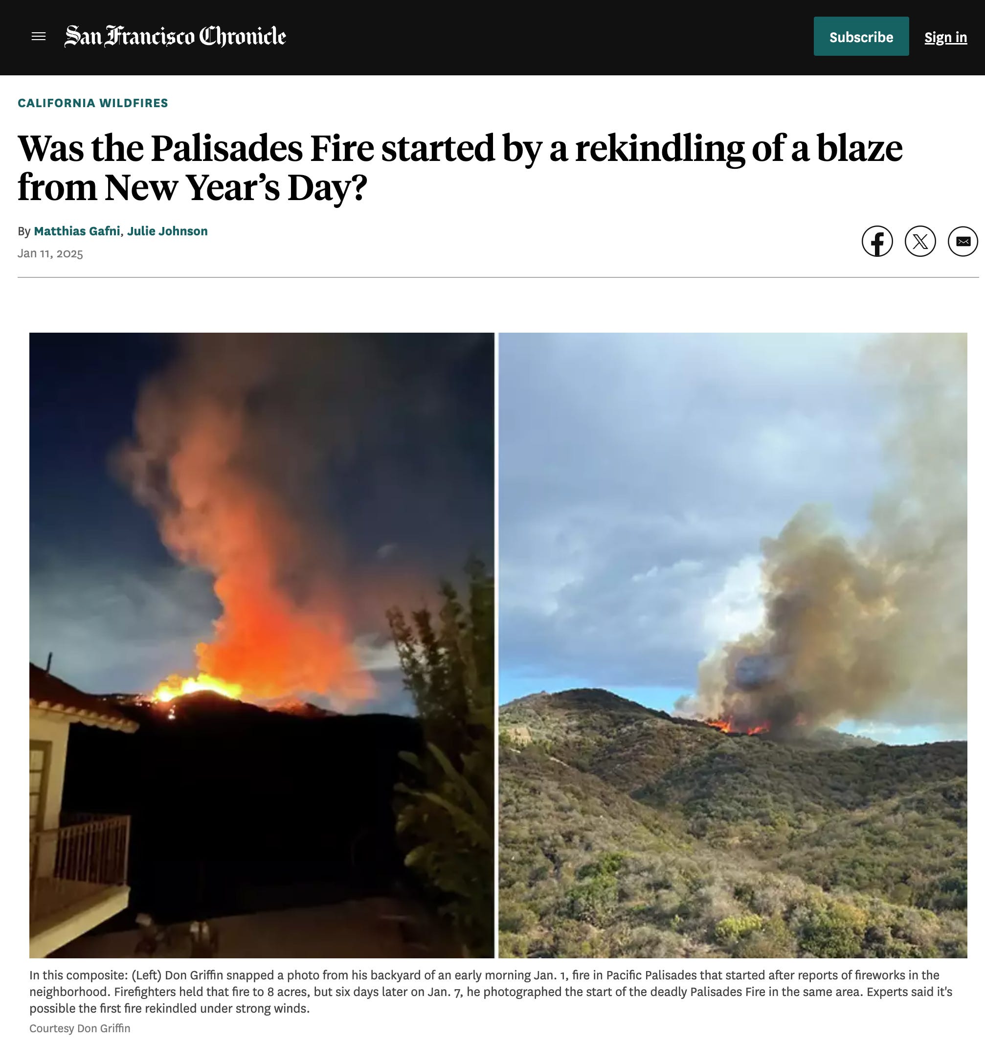
On January 7, 2025, a fire tore through the Pacific Palisades, destroying thousands of homes and upending the lives of residents across the community. What some do not realize is that this was not the first fire to erupt at that exact location this year. A week earlier, at midnight on January 1, another fire broke out at the exact same point along Temescal Ridge.
Almost immediately, rumors spread — most commonly, the claim that “teenagers with fireworks” were responsible. But as time has passed, no public evidence has surfaced to support this theory. The community is left with unanswered questions, recycled narratives, and an official silence about the actual cause.
Video shot by Sara Shuman, President of HOA#1 on January 1, 2025. HOA#1 burned to the ground on January 8, 2025.
The reality is that investigators today have tools available that go far beyond eyewitness accounts or neighborhood rumors. With geo-spatial-temporal analysis — known as geofencing — it is possible to reconstruct who was present, where, and when, with remarkable precision. These methods have been employed in high-profile arson, criminal, and wildfire investigations throughout the country.
So the real question isn’t just what happened on those nights in the Palisades. It’s also whether these powerful investigative tools are being fully utilized by officials now tasked with finding answers. Is anyone in charge of making use of all the data at their disposal? And if not, why?
This article examines both the events and the investigative possibilities. In a digital age, relying on rumors when hard evidence is within reach is not just a missed opportunity — it’s a disservice to every resident still searching for the truth.
Background: Fireworks, Tagging, and Gang Activity in the Palisades
Incidents involving fireworks, tagging, and group gatherings have repeatedly shaped the safety landscape in Pacific Palisades. On October 2023, a series of events set the stage for what followed in the community. The night of November 20, 2024, brought a late-night explosion reported at the Recreation Center, raising immediate concerns about fire hazards.
By November 24, taggers had painted the bluffs — a case later detailed by Circling the News in an article about the limits of enforcement and the persistence of illegal activity (Stopping Fireworks Will Take More than Enforcement).
As December began, the Malibu Fire provided the backdrop for further disturbances. After midnight on December 10, I personally witnessed singing and suspected tagging in Bluff Park, highlighting a pattern of late-night gatherings even during active wildfire emergencies.
A video of the Malibu Fire recorded on December 10, 2024 by the author. There were several youths behind me singing that I walked past, and it appeared that the fences had been recently tagged.
Moving toward the end of the year, fireworks activity escalated. Residents on Radcliffe Avenue documented teens setting off fireworks with enough force and frequency to prompt calls to law enforcement, a story confirmed by local reporting (Illegal Fireworks Set off on Radcliffe Avenue). Officers responding to the scene identified the event’s proximity to a Very Severe High Fire Hazard Zone, illustrating the ongoing risk.
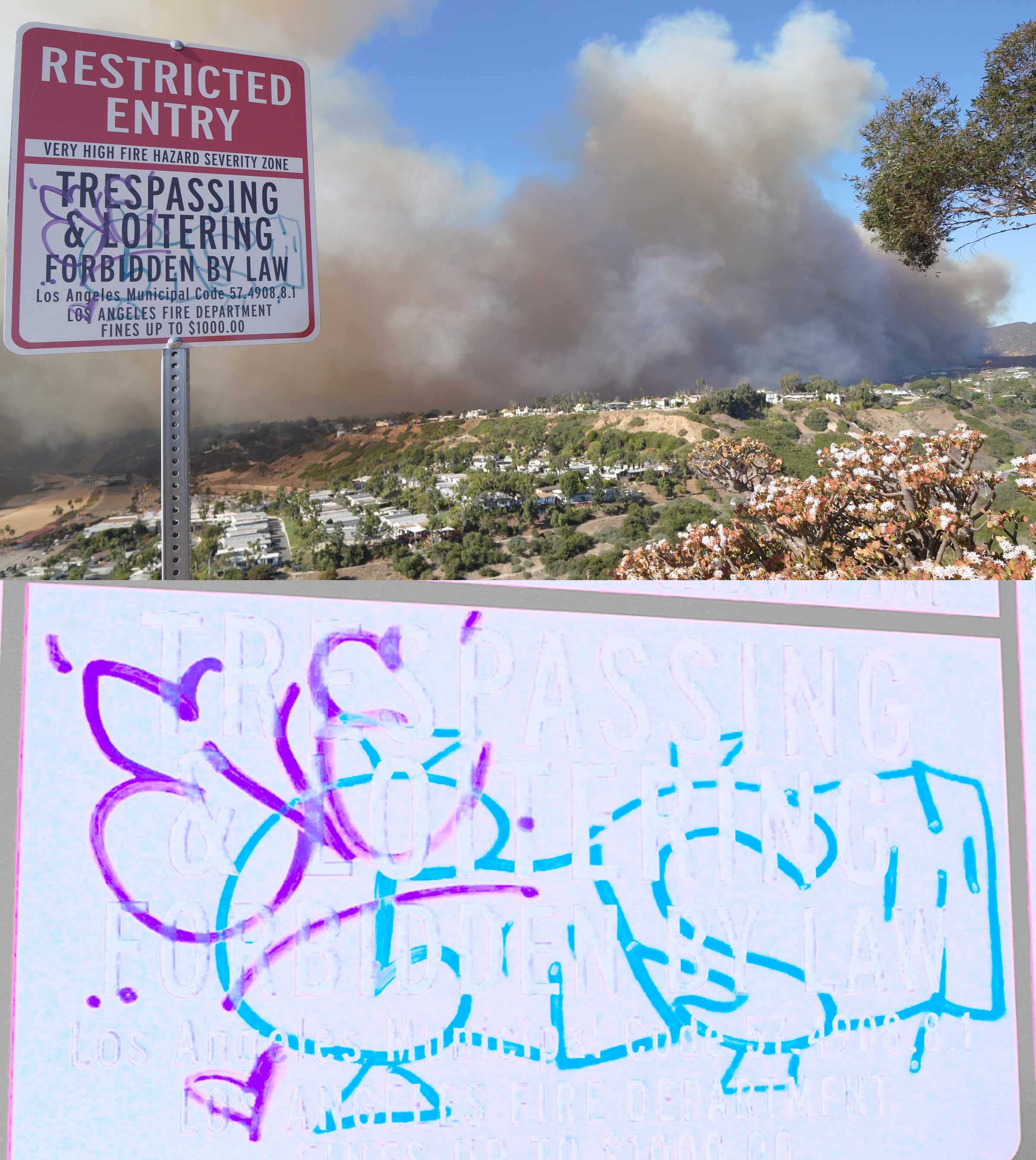
In the lead-up to the January 7 disaster, tagging incidents included the defacement of fire warning signs at the bluffs, which generated digital reports. If the Pacific Palisades Community Council and/or Chamber of Commerce coordinate graffiti removal, this evidence may potentially be vital in identifying potential suspect vectors. By utilizing digital submissions — photos, app-based reports, and location-tagged evidence, investigators could corroborate with digital ping data from mobile phone beacons.
Video posted by “Benji Oren” on Twitter, and said individual appears in the video, and we hear the videographer call his name. Did they call 911 before starting their video?
On January 1, 2025, a group near Skull Rock, led by someone calling themselves “Benji Oren,” appeared on a video moments after the fire started, providing a digitally timestamped visual record of presence in the area. Ping data can be used to corroborate or disprove alibis.
Thanks to my readers' generosity, all my articles are free to access. Independent journalism, however, requires time and investment. If you found value in this article or any others, please consider sharing or even becoming a paid subscriber, who benefits by joining the conversation in the comments. I want you to know that your support is always gratefully received and will never be forgotten. Please buy me a coffee or as many as you wish.
This steady accumulation of digital records, eyewitness accounts, and official responses marks a shift in how threat environments are tracked and understood. What if the data streams generated for graffiti removal, fireworks enforcement, and community response offer a foundation for deeper analysis of the fires on January 1 and January 7? These digital traces, when combined with geofencing tools, define time, place, and recurrence with precision.
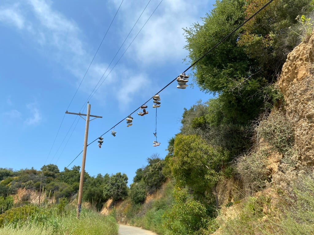
Graffiti and related markers do not occur in a vacuum. Tags, distinctive symbols, and even shoes thrown over telephone wires often carry specific meanings understood within local gang culture or among groups seeking to establish territorial claims. These signals can indicate boundaries, alliances, warnings, or the presence of illicit activity. Their appearance in the context of other risk factors—such as fireworks and late-night gatherings — can provide valuable context for investigators. By examining these visual markers alongside digital evidence, officials can develop a clearer picture of group dynamics and potential motivations that may otherwise go unnoticed.
The devastation of January 7 elevates the need for inquiry rooted in the specific, the verifiable, and the traceable. Events that once faded into background noise now stand as structural elements in the timeline leading to disaster.
Modern Investigation Tools: Geo-Spatial-Temporal Analysis
Almost everyone in the modern world carries a device that continuously generates a digital record of movement. Each mobile phone communicates with cell towers, Wi-Fi networks, and app servers, producing a steady stream of location pings — each marked with a unique device identifier, a timestamp, and geographic coordinates. Routine activities, from opening a navigation app to accepting app permissions, create a permanent footprint.
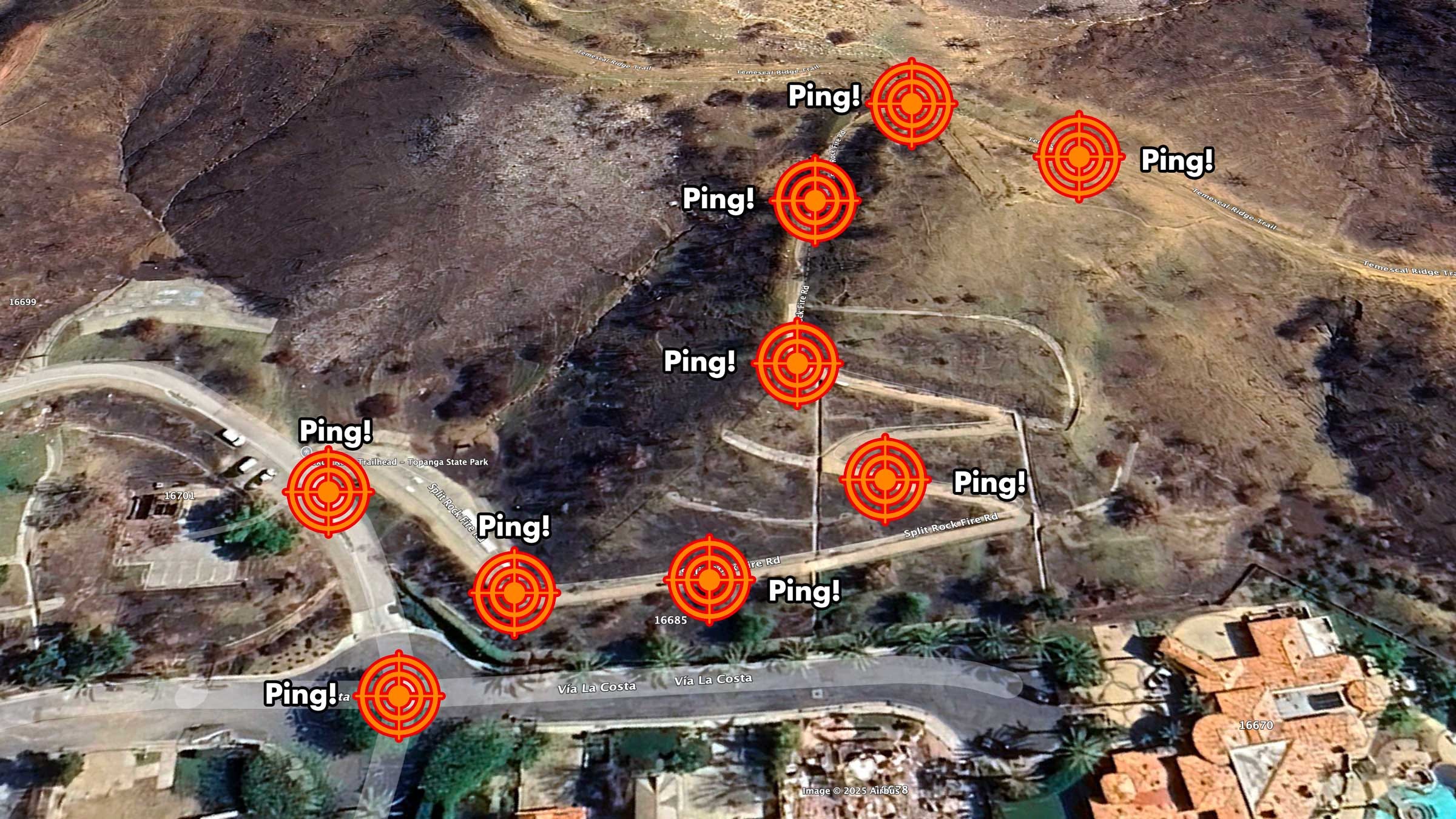
Investigators now have the ability to use this data to answer foundational questions about any fire: who was present, when, and for how long. The process starts with geofencing, which establishes a virtual boundary around a real-world location, such as the ignition site of a fire. It is then possible to obtain historical mobile location data for that specific area and time.
Geo-spatial-temporal analysis combines location, device ID, and timestamp. While these device identifiers do not provide names, their movement patterns over days or weeks often reveal home locations, workplaces, and daily habits. This allows analysts to distinguish between residents, workers, visitors, and outliers.
The data is collected and aggregated by vendors through app permissions, ad networks, and mobile operating systems. Every user who taps “I Accept” to location sharing often contributes to this data pool. Agencies, consultants, and researchers often purchase access for law enforcement, security, or academic research purposes.
Specialists in data forensics process these datasets to create visual maps and timelines, showing which devices entered, exited, or remained within a geofence at key moments. The resulting analysis does not name individuals but can reveal repeated patterns, coordinated activity, or, in some cases, suspicious absences.
Given the scale of destruction and the stakes involved, it is essential that those responsible for the investigation — including the Los Angeles Fire Department, the Los Angeles Police Department, the Bureau of Alcohol, Tobacco, Firearms and Explosives (ATF) led by Special Agent Jose Medina, the Federal Bureau of Investigation (FBI), and elected officials such as Councilwoman Traci Park—fully leverage these tools. Geo-spatial-temporal analysis allows investigators to eliminate false leads, evaluate competing explanations, and generate actionable insights. In a case of this magnitude, digital evidence represents a critical and readily available resource. The community deserves assurance that these agencies and officials are utilizing every tool at their disposal.
Palisades Fires & Related Events: Timeline with Coordinates, Map Links, and Sources
October 2023
Tagging and group activity reported, shaping a new risk landscape in the Palisades.
Source: Stopping Fireworks Will Take More than Enforcement – Circling the News
November 20, 2024, 1:44 AM
Explosion/fireworks reported at the Palisades Recreation Center.
Coordinates: 34.04251599701247, -118.52457847830706
Source: Stopping Fireworks Will Take More than Enforcement – Circling the News
November 24, 2024
Tagging at the bluffs.
Coordinates: 34.0357706944748, -118.53262050295749
(Photo above)
Late December 2024, date needed
Tagging of the fire warning sign at the bluffs.
Coordinates: 34.03596633103596, -118.53324859426397
(Photo above)
December 10, 2024, Midnight–3:00 AM
Singing and suspected tagging in Bluff Park during the Malibu Fire.
Coordinates: 34.03593459140322, -118.53305975090775
(See video above)
October 18, 2024, 10:00 PM
Fireworks set off on Will Rogers Beach (Red Flag day).
Coordinates: (Will Rogers Beach)
Source: LETTER: Activist and LAPD Commander Discuss Fireworks, 911 Calls – Circling the News
October 20, 2024, Friday night
Illegal fireworks set off at Radcliffe & Bowdoin during Palisades Charter High School homecoming football game.
Approximate coordinates: 34.0459229109912, -118.53001746641185
Source: Illegal Fireworks Set off on Radcliffe Avenue – Circling the News
January 7, 2025, Morning (~9:00 AM)
Benji Oren records video and posts from Skull Rock as the fire began, providing real-time video evidence at the moment of ignition.
Skull Rock Coordinates: 34.07081068869666, -118.54287693603122
Fire origin site: 34.075763101060055, -118.5448610753198
Sources: (Eyewitness/video documentation)
January 15, 2025
ATF Assigned Investigation
Sources: ATF Calls In Elite Team Of Fire Investigators For Palisades Probe – Patch, ATF to conduct controlled fire to determine Palisades Fire cause – CBS News
How Data Trails Can Support or Eliminate Theories
Investigations that rely on digital location data no longer need to settle for speculation. Each mobile device that enters or leaves a defined area creates a record — an anonymized but unique trail of presence, movement, and duration. These digital trails become foundational evidence in determining what did or did not happen at a specific location and time.
When investigators analyze historical device data within a geofence drawn around the fire’s ignition site, they can gain an objective log of every device present during the relevant window. If several devices appear in the area at the time the fire started, the pattern may suggest casual visitors, residents, or, in some cases, potential suspects. If those devices match other locations, patterns of life can be investigated.
Patterns of repeat presence, coordinated arrivals, or simultaneous device departures can highlight group behavior. When a single device appears at multiple related incidents, investigators gain leads that warrant further review. Conversely, a total absence of devices can eliminate certain hypotheses from consideration, allowing investigators to focus resources more efficiently.
If no devices appear, that absence itself raises new questions: Are disciplined bad actors deliberately avoiding detection, or does the absence undermine popular explanations, such as the claim that local teenagers with fireworks were responsible?
This approach is not theoretical. In the 2020 Denver arson case, investigators used digital evidence and device trails to identify suspects involved in a deadly house fire, ultimately narrowing the search based on device movements and search histories. In another instance, law enforcement utilized geofence warrants in a Virginia bank robbery to rule out bystanders and focus the investigation on the actual perpetrators. These cases demonstrate that digital location data can either corroborate or challenge working theories, streamlining the investigative process.
Digital evidence cannot always identify a perpetrator, but it narrows the field. The ability to confirm, challenge, or eliminate theories through data represents a leap beyond the limitations of rumor, eyewitness memory, or after-the-fact reconstruction. For an event as consequential as the fires of January 1 and January 7, applying this technology means replacing speculation with testable, reviewable results.
The Role of Rumors and Narrative Control
Major incidents often generate stories that circulate rapidly through a community. In the aftermath of both the January 1 and January 7 fires, one explanation took hold almost immediately: that “teenagers with fireworks” were to blame. This account spread before any formal evidence had been shared with the public.
Rumors fill the void left by uncertainty and official silence. Sometimes, they originate organically, reflecting residents’ memories of prior incidents involving fireworks, tagging, or late-night gatherings. At other times, narratives are adopted or amplified because they offer a simple, familiar explanation that requires little further investigation.
There are also cases where rumors serve strategic purposes. If a coordinated group seeks to deflect suspicion or delay investigation, encouraging a popular rumor can function as a form of narrative control. I have documented this epistemological warfare technique in other posts and described this tactic as “flooding the zone” — a method of introducing competing stories or distractions that make it more difficult for investigators and the public to focus on verifiable evidence. The fact that it is happening can be evidence of the presence of bad actors.

In the case of the Palisades fires, repeating a story about unsupervised teenagers risks crowding out alternative explanations, including the possibility of deliberate or organized action. When communities and investigators accept a single narrative too quickly, they can overlook evidence that might lead in a different direction.
The only remedy for this kind of epistemological vulnerability is transparency and access to hard evidence. Digital data, when made available for review, helps ensure that theories are tested, not simply accepted. Narrative control loses its power when facts are open to scrutiny, and every claim must stand against the available record.
Transparency and Public Oversight
Transparency is a prerequisite for public trust in any investigation of this scale. When evidence remains restricted to a small group of officials, or when investigative methods are not disclosed, speculation fills the void and confidence erodes. The community’s interest is best served when both the process and the findings are subject to independent scrutiny.
Investigations that uses geo-spatial-temporal data must be fully transparent. The public should have access not only to official findings and summary reports, but also to the raw, underlying data. This level of access ensures that independent investigators, journalists, legal advocates, and community members can examine the data themselves, verify the conclusions, and even conduct their own analyses. In practice, this means making raw device pings, geofence definitions, and analytic procedures available to anyone who wishes to audit the process.
True public oversight is only possible when all evidence can be interrogated by more than one party. Open review increases the likelihood that errors or oversights are caught and corrected. When different parties can examine the same evidence, the process becomes more robust and the conclusions more credible.
A commitment to data transparency signals that the investigation is not a closed or self-serving exercise. Instead, it acknowledges the rights of those affected—including displaced residents—to examine, question, and understand the full basis for any official findings. For the fires of January 1 and January 7, public oversight requires that all relevant digital records, analytical methods, and decisions be open to legitimate inquiry by anyone qualified and willing to review them.
Accountability and Resources
Accountability begins with determining who is responsible for conducting and overseeing the investigation. Regarding the January 1 and January 7 fires, the key agencies and officials include the Los Angeles Fire Department, Los Angeles County Fire Department, Los Angeles County Sheriff's Department, the Los Angeles Police Department, the Bureau of Alcohol, Tobacco, Firearms and Explosives (ATF) under Special Agent Jose Medina, the Federal Bureau of Investigation (FBI), and Councilwoman Traci Park.
It is reasonable to expect these agencies and officials to use all available resources and modern investigative tools, including geo-spatial-temporal analysis, to determine the facts. If any agency claims that budget or technical limitations prevent the use of these methods, public and private solutions exist. Philanthropists and civic-minded individuals, such as those with the resources and commitment of Rick Caruso, can fund the acquisition of data and analysis. Public pressure and community advocacy can also ensure that officials cannot avoid digital evidence due to resource constraints.
The community has a right to know what tools are being used and what investigative standards are being applied. Refusal to employ available technology, or to make results and raw data public, should be treated as a failure of duty. In a disaster of this magnitude, with so many lives upended, there is no justification for withholding modern investigative methods or for shielding the process from public accountability.
Conclusion
The fires of January 1 and January 7 devastated Pacific Palisades, forcing every resident to confront urgent questions about risk, responsibility, and truth. In an era defined by ubiquitous digital records, investigators now have access to tools and data that enable them to move beyond rumor and speculation. Geo-spatial-temporal analysis, when used transparently and subject to public oversight, transforms the investigation of disasters from a process rooted in narrative to one grounded in evidence.
This is not a witch hunt. When thousands lose their homes and lives are disrupted, it is not enough to accept familiar stories or let rumors stand untested. Every official and agency with a role in the investigation has an obligation to employ every available resource, to share all relevant data, and to invite independent scrutiny. The community must insist that the facts, not anecdotes or expediency, form the basis for recovery and prevention.
Modern technology does not guarantee truth, but it gives the public a path to pursue it. The future of Pacific Palisades — and the credibility of those who lead it — depends on a willingness to use these tools openly, share evidence freely, and accept nothing less than a fully accountable investigation.
Geo-Fencing Data & Investigative Resources
Commercial Data Providers
Near Intelligence – Large-scale location intelligence and movement data for commercial, research, and security clients.
Gravy Analytics – Consumer movement data, location analytics, and visit verification for business and public safety.
Veraset – Raw, high-frequency mobile device location data for research, planning, and forensic analysis.
SafeGraph – Point-of-interest and mobility data, often used for research and public safety applications.
Babel Street – Location intelligence and open-source analytics for corporate and government clients.
Fog Data Science – Mobile device geolocation analytics for law enforcement and investigative clients.
GeoComply – Geolocation fraud prevention and forensic solutions for industry and government.
Securus Technologies – Location-based services and digital forensics for law enforcement.
Forensic Investigators & Consultants
Berla Corporation – Digital forensics with expertise in vehicle and mobile device data extraction for investigations.
Epiq Global – Mobile device analysis and digital forensics for legal, regulatory, and insurance matters.
Cellebrite – Global leader in mobile device forensics, widely used by law enforcement and fire investigators.
Kroll – Digital Forensics – Mobile and location forensics for criminal, civil, and insurance cases.
Envista Forensics – Fire investigation and analysis with digital and mobile data capabilities.
Stroz Friedberg (Aon) – Digital forensics, cyber investigations, and data analytics for litigation, insurance, and disaster review.
Investigative Agency
ATF National Response Team – Federal team specializing in fire and arson investigations, often using digital evidence.
Research, Journalism, and Legal Analysis
Lexipol – Geofencing in Law Enforcement – Overview of geofencing techniques and law enforcement use cases.
Upturn – Mass Extraction Report – Investigation into law enforcement’s use of mobile data extraction tools.
Electronic Frontier Foundation – Geofence Warrants – Legal and civil liberties analysis of geofence warrants.
WIRED – Denver Arson Case – Case study on how mobile data led to arson suspects.
New York Times – Geofence Warrants and Wrongful Arrest – Example of both investigative value and risk.
Local News & Documentation – Pacific Palisades Fires
Stopping Fireworks Will Take More than Enforcement – Circling the News
Illegal Fireworks Set off on Radcliffe Avenue – Circling the News
LETTER: Activist and LAPD Commander Discuss Fireworks, 911 Calls – Circling the News
ATF to conduct controlled fire to determine Palisades Fire cause – CBS News
ATF Calls In Elite Team Of Fire Investigators For Palisades Probe – Patch
ATF National Response Team Mobilizes to Investigate Cause of the Pacific Palisades Fire – ATF.gov
How Globalist Arsonists Have Used Fire to Seize Control of Los Angeles

On January 7th, a wave of fires tore through Los Angeles and the Pacific Palisades, leaving destruction in their wake. Applying the principle of Cui Bono — who benefits? — it becomes evident that these fires were not just a tragic accident. The overwhelming evidence suggests that Nicolas Berggruen and his Berggruen Institute directed the implementation …
California’s Digital Enslavement: Nicolas Berggruen’s Plan to Turn the State into an AI-Controlled Prison

Thanks to my readers' generosity, all my articles are free to access. Independent journalism, however, requires time and investment. If you found value in this article or any others, please consider sharing or even becoming a paid subscriber, who benefits by joining the conversation in the comments. I want you to know that your support is always gratefu…
Palisades Firestorm: How AI and Corruption Are Burning California to Ashes

Thanks to my readers' generosity, all my articles are free to access. Independent journalism, however, requires time and investment. If you found value in this article or any others, please consider sharing or even becoming a paid subscriber, who benefits by joining the conversation in the comments. I want yo…
Disaster in the Palisades - Part II

This is the second half of a video we started at the beginning of this event. Unfortunately, the first half did not have audio. We are producing this half with what equipment we have left and will combine the two halves when we have a little more time.
Amazing info and research.
Wonder if “authorities” will ever do anything.
Very thorough, well organized coverage of a complex issue. I support your efforts to really solve this, yet must admit a reluctance to using our surveillance system so extensively. But this type of information is already being used, isn't it? It reminds me of reports about all the back doors embedded in our devices, yet still the government has sued (Apple, in one case, I believe) in the past to "unlock" a phone in a controversial case a few years ago. So was that real, or just for show? Everyone is trying to sell encrypted/"secure" phone/pc systems, etc. Are any of these really credible products, or are they just the latest in marketing? But back to the Palisades Fires, has Richard Grenell been of any assistance? You have reported difficulties with your insurance, for example. He should be operating as an ombudsman for the community. Also, there is something poignantly beautiful about that lemon tree you photographed.